 Live Music Archive
 Librivox Free Audio
 Metropolitan Museum
 Cleveland Museum of Art
 Internet Arcade
 Console Living Room
 Books to Borrow
 Open Library
 TV News
 Understanding 9/11
tv America This Morning ABC October 30, 2012 4:00am-4:30am EDT
4:00 am

>> always scared i was going to drown. it was just crazy. >> straight ahead -- it was a long night for emergency crews all up and down the east coast. sandy causing massive flooding, down trees, and power outages, leaving to several rescues as well. good morning, washington. it is use morning, october 30. >> unbelievable pictures to share with you. now, throughout our newscast, we're going to scroll area closures along the screen. we want to get right over to jacqui, who's been following the situation all night into this early morning and joins us with the latest. >> good morning, guys. the worst is over.
4:01 am
that's the best thing i can tell you. still lingering impacts. sandy no longer a hurricane, but still packing winds. take a look at the satellite and radar picture. you can pick out the center of circulation t. is moving across central pennsylvania at this time up to our north, and it's moving off to the west. we're going to continue to get some rainfall here this morning, occasionally off and on, and our temperatures are so cold, a little snow mixing in from the west. of course, the higher elevations getting hit hard now with some snow above 2,000 feet, where blizzard warnings remain in effect. flood alerts all across the area. a flash flood watch and warnings. many rivers and streams are out of their banks, and there's so much water we received from sandy that it's going to take a long time for all that to funnel down into the bigger rivers and streams and make its way over towards the atlantic ocean and get out of here. so many of the rivers will be in flood through a good part of the week. our winds still pretty gusty at this morning.
4:02 am
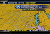
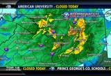
on average, about 25 to 30 miles per hour. we could still see some 30 to 35 mile per hour gusts throughout much of the morning. here's some of the weak wind gusts that we received. piney point maryland, 75 miles per hour. point lookout, 74 miles per hour. 74 and above is considered hurricane force. colesville, 70 miles an hour. and annapolis, 69. reston had a wind gust at 60 miles per hour. high wind warnings remain in effect right now from the national weather service, but i do expect these are going to be dropped or at least downgraded to a wind advisory for this morning. your express forecast for today remaining cloudy and windy at 9:00 with some lingering showers, 44 degrees. only 46 by noon. still some rain and clouds. and by 5:00, i think that rain is going to be out of here still breezy but we're only looking at maybe 15 to 20 mile per hour winds by that time. so the worst is over. we'll grad weight improve throughout the day.
4:03 am

we'll have more reports from the storm and other weather observations to talk more about this river flooding coming up. back to you. >> all right, thank you so much jacqui. it's 4:02 right now. want to bring you some of the latest headlines from the storms, but first let's check in now and get the latest from traffic. >> ok, we can do that, definitely cynne. as i look around the region and speak to everyone who's been working, police, fire, and rescue, we have a lot of areas where we still have the potential of flash flooding. so it's really important to avoid being on the roads and watch your step very closely for debris as well. now, we have the bay bridge each direction, the bay bridge, they closed that yesterday, so do keep that in mind. a couple of closures remain in colesville road, back to you. >> thanks so much. well, the massive storm being blamed for at least 13 deaths in the united states. >> sandy flooded tunnels in new york city, along with subway
4:04 am

stations, the electrical system, the power to wall street. power out for more than five million customers across the east. it's unlikely that the full extent of the storm's damage will be known until date. let's update on you what's happening here in the d.c. region. >> so pepco reporting 32,000 customers in the dark this morning. dominion virginia power has more than 122,000 without electric today. and b.g.e. reporting more than 215,000 outages. novec has nearly 23,000 customers without power this morning. also, you should note that schools and government offices all across the region closed today again today. >> and you're going to find another way to get to work if you have to go. if you use mass transit, no metrorail or bus service this morning. marc or v.r.e. trains not running. amtrak has cancelled all northeast corridor trains. all flights at the d.c. area's three major airports are cancelled today.
4:05 am

we're going to go to ocean city maryland, where the boardwalk, as we mentioned, received extensive damage. >> brianne carter was there throughout the storm and has been following the conditions the past couple of days. how's it looking there this morning? >> hey, brenda? >> all right we're having a little trouble catching one her right now. you can see how breezy it still is out there in ocean city. that's where we started to feel a lot of it. big storm coverage happened up in new york, and that's where they're still having majority of the problems this morning. >> a lot of video we're going to share with you. do we have that video from coney island? i understand that there are some -- there's extensive damage there. >> all right we're going to take a look at some of -- >> there we go. this is coney island. you can see just how much water there is. it's flooded. it's completely flooded. what a mess. >> and this is the scene across
4:06 am

long island. breezy point, there was a huge fire that was attributed to the storm as well. let's look at other pictures coming in from new york right now, if we can scroll through some of these right now. up in the wee hawken area, and we'll see if we can pull that up now. >> pretty dramatic rescue that took place. this is a picture from that situation. this was a problem in so many parts over the east coast where people ventured into water. they didn't realize how deep they were, and that's when emergency crews had to jump in and do these rescues. >> rockaway park in queens, fire department folks trying to help some people. east river look at how high the waves are from the east river overflowing in long island stefment >> the hoboken path station this is like the metro, the pap system in new jersey, you can see the water faul, the stair well there. >> looks like an elevator there.
4:07 am

>> an elevator shaft wow. the clean-up is going to be quite a task this morning. >> a couple of views up to the north. we're going to continue our special coverage near d.c. in just a minute, we'll have a live report from huntington county. >> we would love to see your photos and videos, so send them to us at iwitness@.com.


4:10 am

>> just about 10 minutes after 4:00 this morning. our coverage of sandy continues with heightened fear for homeowner in the huntington section of fairfax county. >> they're concerned they should see a repeat in the flood-prone area. our john gonzalez there this morning live with a look. john, good morning. >> good morning, cynne. that is still the concern here this morning. fairfax county police and fire have set up an emergency command post, if you will, here in the huntington shopping center. you can see there are rescue equipment here and fire trucks, even a city bus. that bus used to assist those evacuated last night. more than 100 homes had stood along cameron run here in alexandria, about 125 homes to be exact, were ordered to leave the area. this of course, a low-lying area very prone to flooding. in fact, there have been some serious flood problems in the past. several years here, many residents spent thousands and thousands of dollars to repair their damaged basements.
4:11 am

now, the water level got as high as six feet during the height of this storm which is right at street level. the fire department did go around and shut off the power to much of the neighborhood as a precaution, but fortunately no reports of any major flooding. now this morning, we're told that the water level over at cameron run is at about four feet, but there's still another high tide at around 9:00 this morning. as you can see perhaps we are still getting a good amount of rain. i hate to say it, but these folks here are not exactly out of the woods yet. the emergency crew here tell us that they will be here throughout the morning. reporting live in huntington, john gonzalez, abc 7 news. >> thanks, john. >> 4:11 right now. let's get back over to jacqui and find out where the storm situation stands right now. >> the storm is no longer a hurricane. it's become extra tropical, as we call it, but it's still packing a punch and we'll still have impact from this storm, especially this morning.
4:12 am
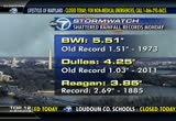
the worst is over, and that's the best i can tell you, but we will continue to see rain. when all is said and done for us in our area, this will be a flood event, the rain will probably be the worst of it. of course, try to tell that to the people who don't have power this morning, right? unfortunately, there's still thousands of you out there in the dark. with you blew away the rain record at reagan national. here's some other numbers to take a look at. purr very well sill, almost eight inches. around 4 1/2 in wolf trap, virginia. we still have flood watches and warnings that remain in effect, and many areas are going to be flooded for a good part of the week. this is a look at the gauges all across the midatlantic and northeast, and all of those black dots that you see there, those are all river gauges that
4:13 am

are in flood at this time. you can see them speckled all over northern virginia and into maryland as well. our wind still gusty right now but gusting to 20 to 30 mile per hour. 30 miles per hour can be expected for the better part till mid-morning before we see them diminish. here's some of the peak wind gusts we've had so far. painy point, maryland, 75 miles an hour, that's hurricane force, and so is the gust of 74 at point lookout. we had 69 mile per hour gusts in annapolis. the high wind warnings they expect will be dropped while they're still in effect across the entire viewing area. our winds diminishing down to about 15, 20 miles per hour this afternoon. temperature widse, chilly. we're only in the 40's right now. in fact, so cold that we might see a few snowflakes off to our west. the higher elevations getting hit hard with blizzard conditions and several feet of snow. it's going to be tough to measure that snow in west
4:14 am

virginia because it's blowing all over the place. another update in just another few minutes, but from the belfort furniture center, let's head over to traffic. >> good morning. we still have a lot going on, so we need to keep all this in mind if you're planning to head out. for starters i want to remind thaw no marc trains, no v.r.e. system, and metrorail closed to the day. again, they made that decision. flights at the airport the amtrak northwest corridor trains, they're also monitoring that very closely as we are as well. taking a look at some of our cameras, we have some of that heavy rain still coming down. maryland, 29. colesville road still remains shut down at lockaway drive. this is near the reservoir here. they closed that in each direction with the high-standing water. just spoke to u.s. park police, it remains closed between east-west highway and down toward the d.c. line. again, because of flooding, we
4:15 am

have that all over the area. so if you know those areas that are prone to high-standing water, the flooding, try to steer clear, back to you. >> 4:15, the temperature is a little bit chillier than it was this time yesterday with the cold front coming through. we're looking at 41 degrees right now. >> much more to come here on "good morning washington." several local homeowners will be spending the week making repairs because of this, down trees throughout the area. we're going to


4:18 am

>> welcome back to washington. it's 4:18 right now. we're giving you live pictures from queens, new york. this is the rockaway peninsula area, specifically the breezy point section of queens. what you're looking at here is a fire an enormous fire, that's now affecting 50 homes in a flood zone area actually.
4:19 am

so there are 200 firefighters out there right now trying to respond to this enormous fire in the midst of floodwater. >> the fire started and spread very quickly because firefighters, when they initially got there, they couldn't get to the scene. they couldn't reach it at first because they were blocked off because of all the water in the area. unfortunately, it just spread from house to house to house, and right now, as you can see from these live pictures in new york city, 50 houses have already been affected in this flood zone, up in the breezy point section of long island. nearly 200 firefighters are still there. dramatic pictures, and they're not going to see the full extent of this until date. >> up to this point, we've learned there are two minor injuries now. you can really get a good look there. gosh, what a mess there. ok all new this morning, want to share this video with you. this is a local picture, an apartment fire sent two people to the hospital in southeast. the fire started in the 2900 block of nelson place. we are told that the victims
4:20 am

are in stable condition this morning. the cause of this fire still under investigation. >> also new video showing more of the damage caused by sandy as the trees slammed into an apartment complex. this is in silver spring. you can see the result. a gas meter was damaged as well, so that caused problems in addition to the physical damage to the home. also found trees and homes on crawford place and good hope road in southeast washington. fortunately, nobody hurt in those tree incidents. we should learn today scrust about how much damage the storm caused here in d.c. >> we've got to wait for the sun to come up. the d.c. mayor is going to tour the city aaccepts the damage, and then hold a briefing on the recovery efforts this afternoon. also, montgomery county executive ike leggett is going to provide an update today on the impact sandy had on the county and what residents can expect over the next several days. maryland state officials also going to hold a briefing. >> virginia governor bob mcdonald asking for federal emergency declarations in response to the hurricane.
4:21 am

this declaration would make funding available to cover costs for emergency protective measures and also debris removal. over the weekend president obama declared states of emergency in d.c. and in maryland. 4:21 right now, 41 degrees on this tuesday morning. >> we got so much more still to come on washington. we'll check back with jacqui and jamie and get updates on the weather and traffic. here's a live look outside right now. looks like this is pretty clear. this is exactly what we want to


4:24 am

>> and good morning washington. i'm jacqui jury is. still wet weather, and we'll still see lingering impacts, especially through this morning. as you take a look at the satellite picture, you can see sandy making landfall over the southern new jersey shore. that was about 8:00 last night, and it's weakened since that time, but still packing a bit of a punch. the center of circulation is right around central park, pennsylvania into this area. so our rain is coming at us from the opposite direction for today as opposed to coming in from the east like it was yesterday. our amounts are going to be a little bit lesser. we still have some wind to deal with. that high wind warning which was in effect just got cancelled and dropped, but it's been replaced with a wind advisory until 2:00 this afternoon. so the wind criteria still lower for that. we could see gusts between 30
4:25 am

and hoe miles an hour, and then it will diminish into the afternoon hours. a little timeline to help you get through the rest of the day. still moderate rain, probably lingering through about 10:00. it tapers after the noon hour. i think we'll be done by 5:00 tonight. there you can see the steady winds still up there in the 20, 25 mile per hour range this morning, and then we'll make it down to about 15 miles an hour as we head into the afternoon hours. it's chilly this morning, isn't it? with the rain coming down, we're getting mixing of snow into the western counties, extreme western counties, and into west virginia, getting some of that heavy snow. our temperature, 43 degrees at this hour, so blizzard warnings remain in effect. skyline drive could get six to 12 inches of snow when all is said and done, and any mixing we might get out here to the west a little snowflake, don't be shocked if you see it, it's all going to melt on contact, so no big deal. here's some of the snowfall reports we've seen so far. so far kitzmiller west virginia, six inches. hightown, virginia, around
4:26 am
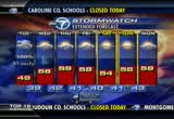
four. cherry grove, around three inches. just about an inch around bayard. we'll continue to see rain showers off and on throughout the morning, maybe a sprinkle through the early afternoon. but i think we'll be done with this for the most part tonight, but a little wraparound early tomorrow morning, only a 20% shot, i can hardly even put it on the seven-day forecast. today, looking for cloudy skies, still windy, a few showers, 44 to 50 degrees, a chilly day. and there's the seven-day forecast, looking good, trick-or-treaters. i know that makes you happy today, but our temperatures will be cool. we'll stay below 60 the next seven days. that's your forecast. let's head over to traffic now. >> good morning. you made a lot of children happy, and adults. as we wake up this morning, what we're dealing with right now, for now, the bay bridge still remains closed. they reopened the key bridge and nice bridges. but again, the bay bridge, they still have that shut down. we have a lot going on as far as watching for debris as we head out and about this morning. the tree limbs we have a lot
4:27 am

of areas where we still have roads closed. we're looking in maryland at 29 and colesville road. this is just north of four corners. that's closed in each direction because of the flooding. road island avenue near north capitol street, flooding as well. we still have rain around the area, as jacqui mentioned. as we take look at a couple of cameras, we can definitely see that coastal road meets west highway, some of the drenching rain still. around the beltway, no problems to report. we still have little falls parkway closed, neal estano specially from the d.c. line. back to you. >> all right, we'll be checking back with you in just a little bit. it's 4:27 right now. we're looking at a much cooler 41 degrees this morning. our our live team coverage continues in just a minute. we're going to look at how down trees will be a problem for residents and f


319 Views
1 Favorite
IN COLLECTIONS
WJLA (ABC) Television Archive
  Television Archive News Search Service
Uploaded by TV Archive on
